
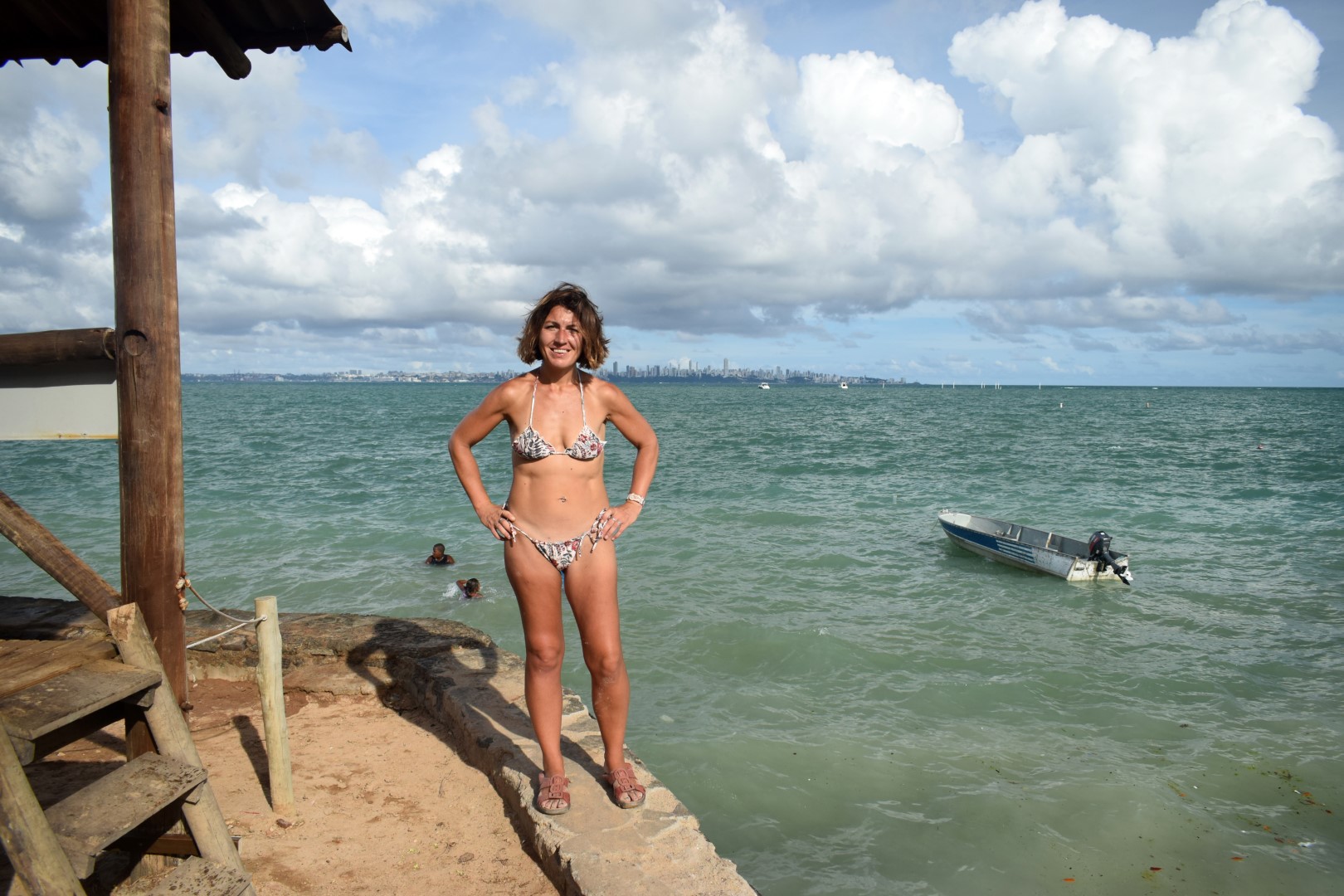
Praia do Farol da Barra and Praia do Porto da Barra aren’t the kind of beach where you can take a relaxing stroll, so I decided to cross the Todos os Santos Bay for longer, quieter and cleaner stretches of sand.
There are tons of islands close to Salvador and tons of day trips too. If you look like a tourist—and unfortunately for me, I do look like… an Argentinian tourist—you can be sure that several times a day, someone will walk up to you with a laminated map in hand to sell you “paseos de barco,” i.e. boat trips around the bay.
Since being stuck on a boat (or on a bus) for a day-long tour is my idea of hell, I decided to pick one island and explore it alone. I stopped by the tourist info at the Elevator Lacerda and I discovered that: 1) there are indeed many islands to choose from 2) most of them are easy to get to by Brazilian standards and hard to get to by my standards.
“This one is pretty close, only 2.5 hours by boat!”
Yeah… no. A five-hours return trip, assuming everything goes as planned and it never does in Brazil.
“What’s the closest island?”
“Itaparica.”
“How long does it take to get there?”
“About 45 minutes… or more in rough sea.”
Doable. I confirmed there was a ferry boat leaving from Cidade Baixa every hour or so and that I wouldn’t get killed if I came back after sunset (Cidade Baixa has a very bad rep). Yes, and probably not. Deal, then.
The next day, I woke up early and walked to Praça Tomé de Souza, then I took the Elevador Lacerda to get to Cidade Baixa and found the ferry terminal behind the Mercado Modelo.
A queue had formed outside the ticket office. Shit. Would I have to wait for the next boat? I paid for my ticket (7 reais, $1.70) and realized that what Brazilians call a “ferry boat” is what I call a “tub” and the sign that said “Capacidade para 200 pessoas” is merely a suggestion. We all climbed aboard, including a dog and travellers with luggage and the boat still waited for a few minutes, as if it wasn’t packed enough already.
Forty minutes later, the boat docked in Vera Cruz, one of the two municipalities on Ilha de Itaparica. I turned down offers of taxi rides and “paseos de barco” and started to explore. To the south, a beach even smaller than in Barra. To my left, a road going to… ah, nowhere.
Thirty minutes later, I realized I was kind of stuck in Vera Cruz and that I should somehow get to the town of Itaparica, to the north, where Google Maps had promised beaches. I ended up taking a taxi and it was worth it—the ten-kilometre walk under the sun and on a busy cross-island road would have been complete suicide.
“I can drop you off here,” the driver suggested. “The Fortaleza de São Lourençiso right here and the beach is behind.”
Perfect. But first, I needed water, or better, coffee. I started walking around in the town of Itaparica. Mercado? Closed. Restaurants, stores? Closed. Main square? Deserted. I found a couple of bars but they only sold beer. Damn it.
Strange place. Never seen a town so quiet.
Never mind, there should be vendors or a mini-market close to the beach.
And by the way, where the fuck was the beach?
There was a low seawall, there were the ocean and that was it. Missing from the picture? Sand.
I asked around—I mean, I asked the three people I saw—and they all pointed to the waterfront. Yeah, got it, Atlantic Ocean right here. But is it a praia if there’s no sand? Come on! This is a… a swimming pool!
I walked around a lot more looking for signs of life on Itaparica—I gave up.
I walked around a lot more looking for the beaches I had seen on Google Maps—I gave up as well after a while.
I tried to find a bus back to Vera Cruz—it didn’t stop at the bus stop, so eventually I just shared a ride with a few strangers.
In the evening, I took the boat back to Salvador.
And sitting on another jam-packed boat I realized I had an awesome day.
I started laughing.
Absolutely not the day trip I was expecting, definitely not what I was looking for but the boat trips from and to Salvador were great and Itaparica is a lovely, relaxing place. Just… a bit too quiet. And a beach would have been nice.
Later that night I checked Google Maps again—it definitely shows pictures of several beaches, most of them with user reviews (!). The best explanation I found is that I was here at high tide and well, there’s no sand at high tide.
That, or I’m crazy.


Beautiful pictures !
Indeed, the island looks nice, even if there’s no beach 😉
The colour of the water was just amazing, I agree!
I’ll have to look through your blogs again; but I wonder if you’ve gone to any of the areas south in Gaucho country, Rio Grande do Sul? My pen pal tells me to visit as it’s full of culture, mostly European and they have great BBQ and nice beaches as well. I am realizing now that Brazil is way bigger and more diverse than I originally gave notice to; it’s like multiple countries all in one, each with it’s quirks and livelihood. I mean before I visited Liberdade, San Bernardo and São Paulo all I knew of Brazil was Rio De Janerio and the Christ Statue and of Carinval. That’s it, that’s what makes your blog interesting, but go places that aren’t known or aren’t even on a map (Google) beach rsrs. Be safe
The South is actually the part of Brazil I know best because I crossed from Argentina and Uruguay quite a few times. Ever heard of Chuy? Don’t go 😆 https://correresmidestino.com/a-night-in-fucking-chui-between-uruguay-and-brazil/
Florianapolis is amazing, I kind f like Porto Alegre (on the gritty side, though), Curitiba is unique in Brazil (colder)…
You’re right, Brazil is much like the US, plenty of small countries that make up a very big country. I came back to Sao Paulo earlier this week (there’s always a small delay between the latest post and where I am because, well, I’m not CNN!) and it’s a real culture shock coming from the Nordeste. Currently exploring a new city… more later 😉
There are so many beautiful beaches in Itaparica. I wish I could share photos here! From the pictures I saw, it looks like you stayed around the pier… you were actually so close. Praia do Forte is right where the driver dropped you off. If, instead of heading back toward the square/market, you had walked in the direction of the Fort of São Lourenço, you would have seen it.
And that’s just one, there are so many others to explore: Praia de Ponta de Areia, Amoreiras, Praia do Brasileiro… on the Vera Cruz side, Praia da Penha, Barra do Gil, Aratuba, and more. I’m sorry you missed those incredible beaches. Happy you had a good day!
This was 100% my own stupidity! I came back and found the beach, or rather beaches, plural. Really, a stupid gringa moment.
That said, the boat trip made my day this first time!